GIS Strategy Roadmap Development
An effective GIS strategy considers the organization as a whole across internal people, customers, business processes, data and technology to ensure lasting organizational change that drives efficiency and improves service delivery. The GIS Roadmap can be used as an opportunity to review your Organization’s GIS plans and identify opportunities to enhance efficiency and effectiveness, thereby streamlining your operations and improving the bottom line.
iSpatialTec provides consulting services for the GIS strategic Roadmap Development, based on international best practices for enterprise GIS development to facilitate the development and implementation of GIS for your organization.
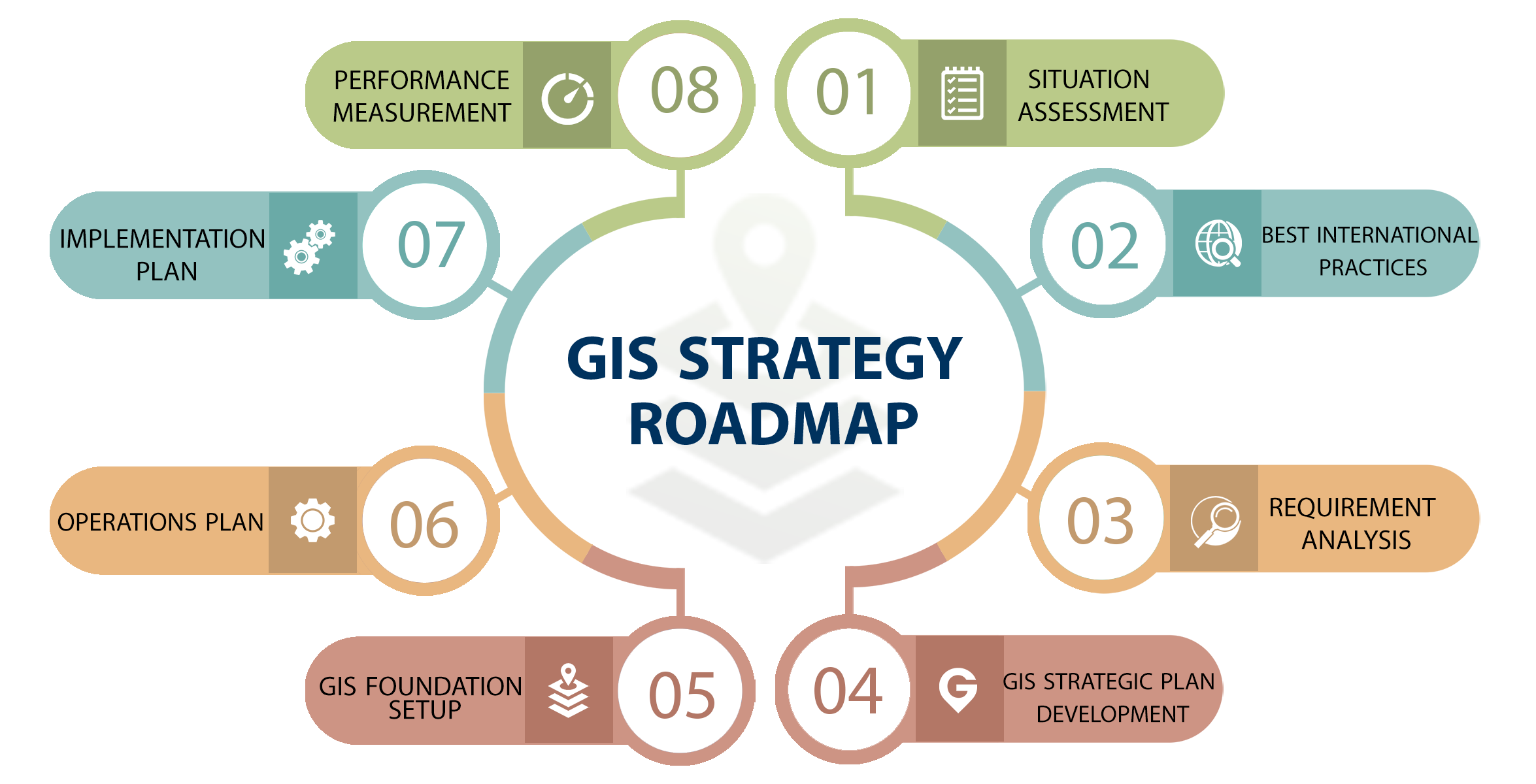
Situation Assessment
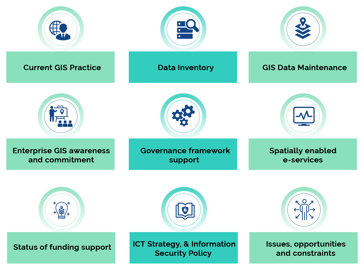
The situation assessment identifies the primary business functions within your organization and then the stakeholders (customers) who conduct these functions. Business functions are distinguished as those that can be geospatially enabled and those that likely cannot. The assessment identifies the capability of departmental units to respond for the stakeholder’s needs and the capacity of the stakeholder to benefit from the provided solution.
The situation assessment identifies the following:
Requirements Analysis
This step involves synthesizing the information discovered in the previous components into a comprehensive set of requirements for the organization. The requirements will be documented for each set of related business functions. During this analysis, it is important to distinguish internal versus cross – external requirements.
The requirements analysis should identify the following:
- Technical requirements for Data, Applications, Infrastructure (systems) and Staff Capacity.
- Data: (Vector or Satellite, Web or Desktop based editing, supporting datasets)
- Security: To adhere company IT security policy.
- Infrastructure: Based on the Gap Analysis, suggest the required infrastructure to remove the Gaps.
- Staff Capacity: Identify any skill level requirement for GIS staff
- Business processes reengineering where necessary and automation, if required.
- Organizational requirements including GIS development and coordination function, staff capacity building, steering committees and working groups, policy, legal, etc.
GIS Strategic Plan Development
The GIS strategic plan provides a detailed perspective and vision for how the organization intends to use GIS for continuous improvement and to attain Geo-maturity in data and applications. The GIS strategic plan may align with the company-wide business strategic goals.
The GIS strategic plan should identify the following:

Vision & Mission and Guiding Principles

Strategic Goals

Implementation approach and Phasing considerations
Operations Plan
The operations plan should be defined to support Program Design and enhance GIS throughout the Organization. This plan should include relevant policies, organizational structure, training programs; and other relevant / required processes and activities to support the program design.
The Operations Plan identifies the following:

Standard Operating Procedures

Stakeholders Community Engagement

Service Level Agreements

Identify best practices and standards for the QA / QC process.

Risk management, if any required

Identify a framework for continued improvement.
Implementation Plan
The implementation plan identifies the priorities and activities required to achieve the strategic plan according to the program design and operations plan. It also highlights any required short-term projects and long-term projects that are required to be initiated in the benefit of organization goal towards Geo-Maturity along with the project implementation methodology that is required.
The Implementation Plan identifies the following:

Short-term and Long-term projects

Implementation tracks

Project milestones and KPIs

Tracks and projects dependencies

Risk management plan
GIS Foundation Setup
In the course of developing the GIS Roadmap and after the Situation assessment phase, we will initiate the creation of foundation environment, activities and practices addressing geospatial data creation, acquisition, management and analysis that provide for initial tangible outputs.
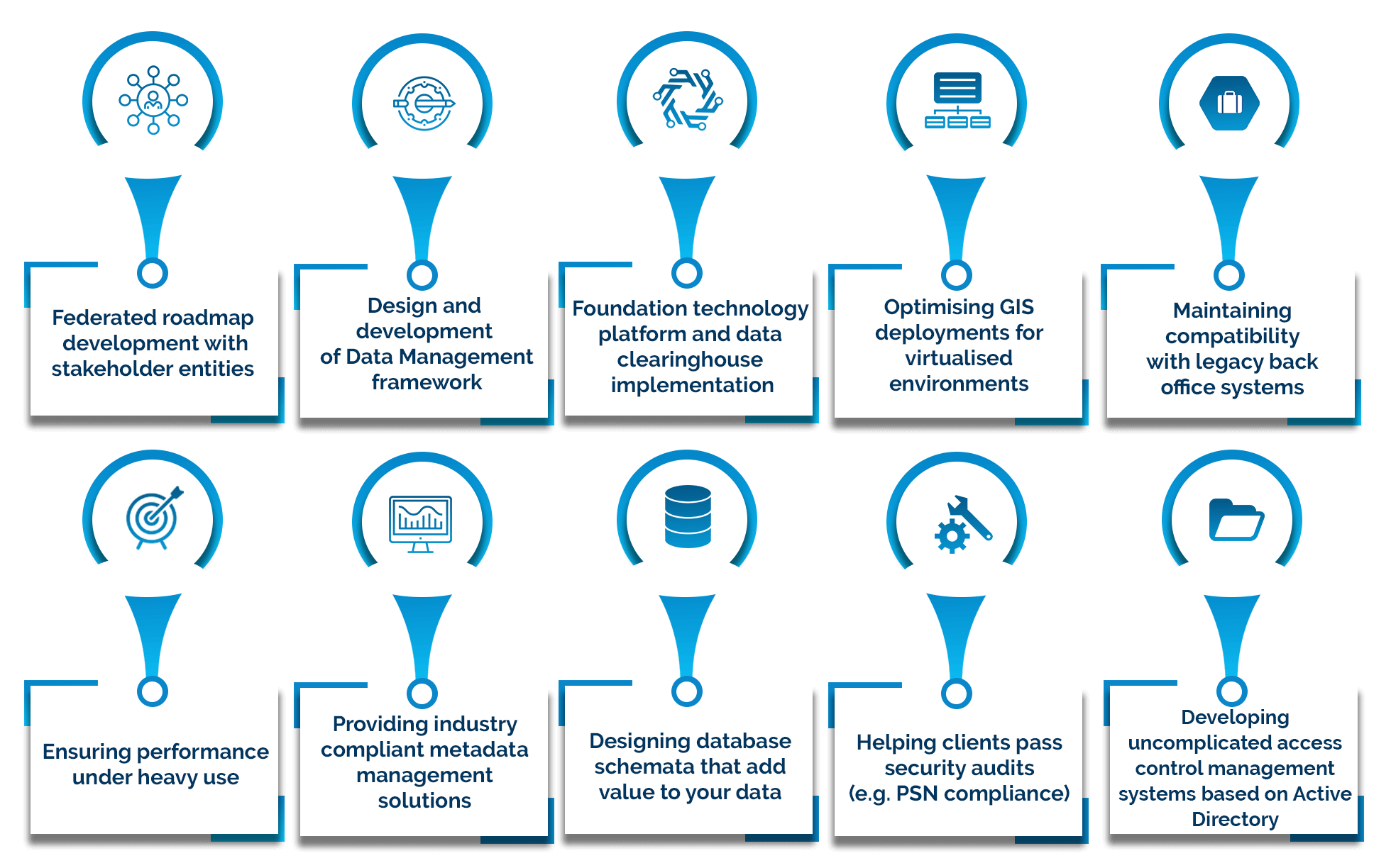
Spatial Data Infrastructure (SDI)
Implementing Spatial data infrastructure (SDI) framework is an effective way to ensure data and resources are available to the organizations and stakeholders that need them while at the same time reducing ongoing licensing costs.
iSpatialTec specializes in utilizing Esri SDI technology integrating with service-oriented architecture (SOA) principles that support existing IT, Web and geospatial interoperability standards, including the industry specifications of the Open Geospatial Consortium (OGC). iSpatialTec helps organizations in improving knowledge sharing, reducing duplication of effort, direct people toward the best available data and improve the overall quality of geospatial data and information.
Our experience includes:
GeoMaturity Assessment
The GeoMaturity model assesses your organization’s program Readiness through evaluating factors related to Enterprise Alignment, Data Management, Infrastructure and Resource Management. These factors build the framework necessary for the second component, Usage. The Usage component evaluates how GIS is used internally to support and enhance operations and how it is presented externally to support communications and smart cities initiatives.
-
Assesses the improvements in turn-around time, elimination of redundant tasks and streamlining of tasks
-
Analyze current operations, identify trends and issues and plan for the future
-
Support mission critical operations and decision making
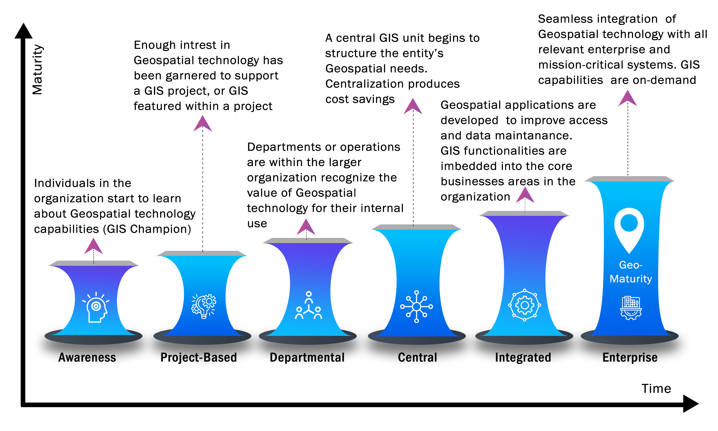
GeoMaturity Model
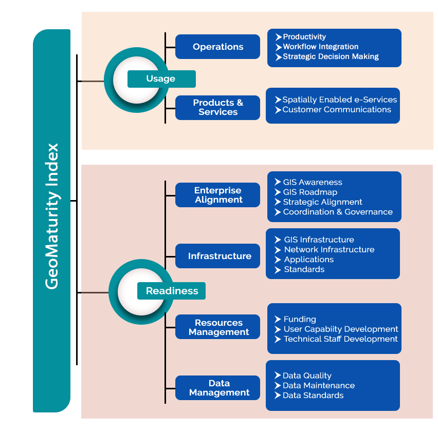
GeoMaturity Index