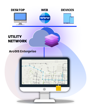
The need for utilities to manage a connected model representing their facilities and assets became a key driver for GIS implementations worldwide. Significant platform upgrades, like Esri's Utility Network, don't have to be just daunting milestones on your organization's technology roadmap. iSpatialTec's GIS and SME can help you navigate these technology changes and realize the maximum value of new technologies. Our business focused approach allows you to implement the latest in GIS technology while minimizing risks associated with change across the enterprise. One of the benefits of implementing Esri's Utility Network is the extensive set of tools and workflows it provides to efficiently create and update your operational data. We are gaining expertise in the utility market and the implementation of solutions or services using the ArcGIS Utility Network Management Extension.
Our portfolio of services includes:


iSpatialTec dedicated team of domain and functional specialists are working with a city government client to help them take advantage of these capabilities. We are also configuring a service-based synchronization between the enterprise GIS and the client's outage management system to view common assets and work orders.